
The Cellar: a friendly neighborhood coffee shop, with no coffee and no shop. Established 1990.
 1 of 1
- xoxoxoBruce
- The Future is Unwritten
 Offline
 - Registered: 10/15/2020
- Posts: 4,355
Maps with Politics
The Silver Dog with the Golden Tail
It seems these days the party planks don’t mean much and are pretty vague in the first place.
So are campaign promises because it’s Congress that does the real damage... er, makes the laws.
Every election finds us fighting more and more over bogus claims and non-issues.
Looks like, oh look over there I’ll watch you wallet for you.
We’re coming up on 250 years old but what were the elections like in the past, say half way.
The 1896 United States presidential election was between Bryan (silver) and McKinley(Gold).
McKinley, backed by businessmen, professionals, prosperous farmers, and skilled factory workers spent
$3.5 million ($113,206,667 today) and won 7,112,138 (51.1%) to 6,510,807 (47.7%).
The tail wagged the dog.
National democratic Party J.M.Palmer 0.93%. Prohibition Party J.Levering 0.33%.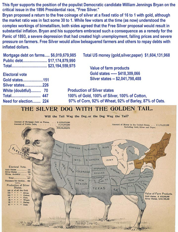
Freedom is just another word for nothin' left to lose.
- xoxoxoBruce
- The Future is Unwritten
Offline
- Registered: 10/15/2020
- Posts: 4,355
Re: Maps with Politics
Reynolds Political Map of the United States in the Cornell Library.
The size is 33.904” x 28.853” with a 251 resolution
An obviously bias or at least slanted comparison of the free and slave states of the 1850's, in the wake of the Missouri Compromise repeal. It has the usual free states are one color, slave states another color, and territories a third color, but scattered around the map are charts with information which mostly comes from the 1850 census and 1852 election. These charts contain information that blows my skirt up, stuff I've wondered about but not enough to go down that rabbit hole, taking forever just to find where to look for each nugget. I mean stuff like how many newspapers, libraries, miles of canals and RR tracks.
Your mileage may vary so I'll understand if I'm not nominated for a Nobel prize.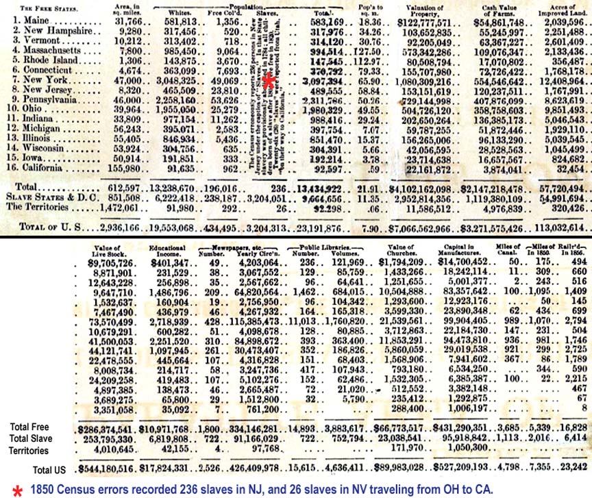
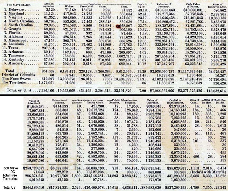
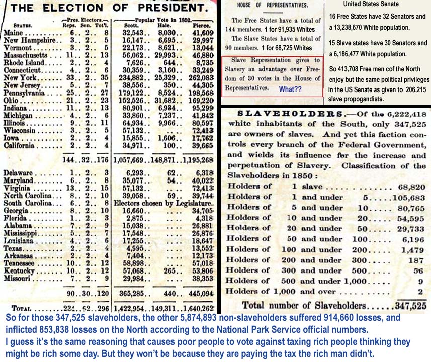
A couple things in the section on the house and senate I had to retype but I believe are accurate.
Last edited by xoxoxoBruce (8/03/2021 9:36 pm)
Freedom is just another word for nothin' left to lose.
- •
- griff
- A Magical Woodland Creature
Offline
- Registered: 10/13/2020
- Posts: 3,160
Re: Maps with Politics
Map with economies: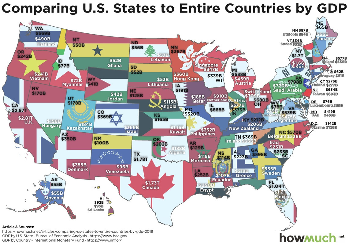
If you would only recognize that life is hard, things would be so much easier for you. - Louis Brandeis
- Happy Monkey
- Member
Offline
- From: DC
- Registered: 10/13/2020
- Posts: 567
Re: Maps with Politics

_______________
|_______________| We live in the nick of times.
| Len 17, Wid 3 |
|_______________|[pics]
- griff
- A Magical Woodland Creature
Offline
- Registered: 10/13/2020
- Posts: 3,160
Re: Maps with Politics
It's a small world after all. (sorry about your ear worm)
If you would only recognize that life is hard, things would be so much easier for you. - Louis Brandeis
- xoxoxoBruce
- The Future is Unwritten
Offline
- Registered: 10/15/2020
- Posts: 4,355
Re: Maps with Politics
Hmm, Japan(Honshu) is bigger than Great Britain, I didn't know that. Would have definitely lost the bet.
Freedom is just another word for nothin' left to lose.
- •
- glatt
- TM
Offline
- From: Arlington VA
- Registered: 10/13/2020
- Posts: 1,234
Re: Maps with Politics
The big island of Hawaii is much smaller than I was thinking. I guess in my mind, I was always comparing it to the other Hawaiian islands and that made it seem big. I remember spending most of a day driving from the eastern side to the western side, but must have been in vacation mode and stopped a lot.