The Cellar: a friendly neighborhood coffee shop, with no coffee and no shop. Established 1990.
- xoxoxoBruce
- The Future is Unwritten
 Offline
 - Registered: 10/15/2020
- Posts: 4,355
Where's Everybody At ?
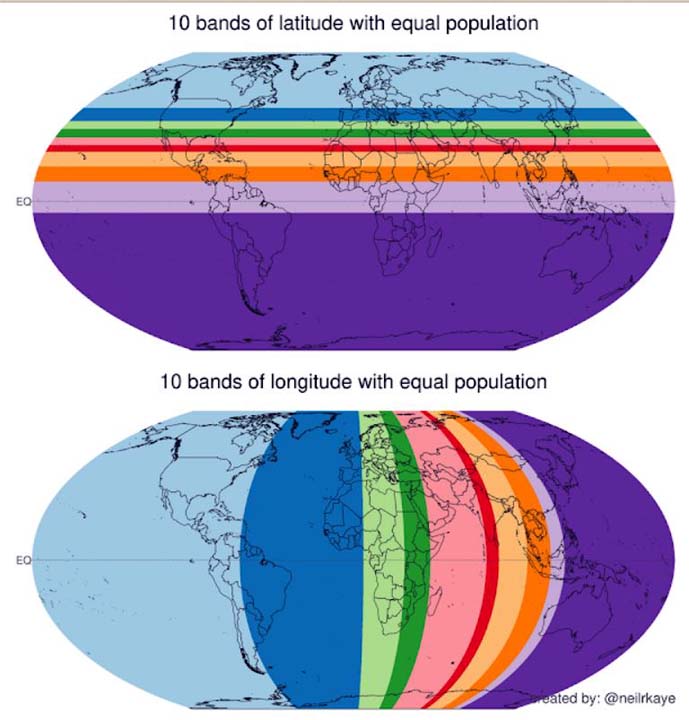
They're divided into 10 bands horizontal and vertical. Where the dense bands overlap it must be standing room only.
Freedom is just another word for nothin' left to lose.
- BigV
- Hold my smoky malt beverage and watch this
 Offline
 - From: the upper left corner
- Registered: 10/13/2020
- Posts: 1,390
Re: Where's Everybody At ?
interesting graphic
so, each band is about 780 million people. would it also be correct to say that where the two narrowest bands intersect (the red bands, somewhere near the center of India) is the most densely populated section of the world?
I wonder what the populations would be the population of the intersection of any pair of bands of the same color. I imagine each section would have the same population.
Be Just And Fear Not
- Clodfobble
- Hella Proactive
 Offline
 - From: Austin, TX
- Registered: 10/13/2020
- Posts: 903
Re: Where's Everybody At ?
BigV wrote:
interesting graphic
so, each band is about 780 million people. would it also be correct to say that where the two narrowest bands intersect (the red bands, somewhere near the center of India) is the most densely populated section of the world?
I wonder what the populations would be the population of the intersection of any pair of bands of the same color. I imagine each section would have the same population.
I think in this case it turns out to be true, but strictly speaking it wouldn't have to be. You could gerrymander things so that, for example, if the population of the US happened to be distributed in a narrow horizontal band across the middle of the country, that would dramatically affect the latitude measurements but not the longitudinal.
 1 of 1